

Zurich Airport becomes first airport to use Google Maps Live View
Posted: 8 October 2021 | International Airport Review | No comments yet
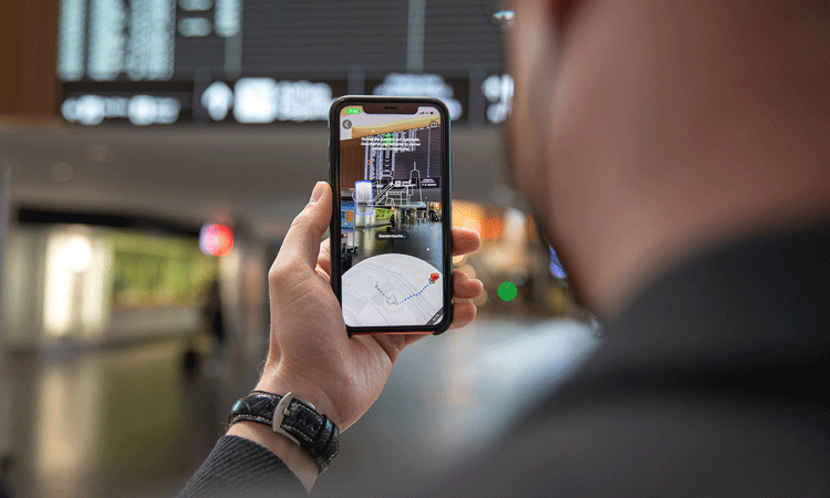
Zurich Airport is the first airport to be equipped with Google’s Live View feature in Google Maps, allowing passengers and visitors to navigate terminal areas using the camera function.
Credit: Zurich Airport
Google has activated the Live View feature in Google Maps at Zurich Airport (ZRH), making it the first airport in the world with this function. Using the camera and directions shown on the camera image, passengers and visitors can navigate to their chosen destination at the airport including finding a gate, check-in desk, or restaurants.
Google Maps Live View uses augmented reality (AR) to help you find your way even more easily. This shared goal led Flughafen Zürich AG and Google Switzerland to launch a project back in mid-2018 to improve intuitive navigation ‘from curb to gate’. Recordings made of the interior of the airport, as well as exterior areas of The Circle, are now being used in the Indoor Live View function of Google Maps. Using Google Maps Live View, the recordings are compared in the background with the user’s camera images to show the correct route in augmented reality view.
Live View uses AR cues and is powered by a technology called global localisation that uses artificial intelligence (AI) to scan tens of billions of Street View recordings to understand your orientation. Due to new advancements that help determine the precise altitude and placement of objects inside a building, Live View can now also be used inside buildings such as airports. Live View can help users find the nearest lift, escalators, the right gate, the platform, baggage claim, check-in or the ticket counter, ATMs, and shops. Arrows and accompanying directions point them the right way.
Join us live: Shaping the Next Generation of Hold Baggage and Air Cargo Screening
Join us live for an insightful webinar on 11th December at 14:00 GMT, in collaboration with Smiths Detection, as we explore the strategic balance of operational efficiency, regulatory compliance, and sustainability in high-volume security environments.
This session offers a focused look into future-proofing your security strategy.
Key learning points
- Cost Reduction: Strategies to minimize bag travel time while simultaneously reducing operational costs.
- Regulatory Roadmap: Insights into the next wave of regulatory changes and their impact on future investment decisions.
- Sustainable Systems: Practical approaches to building sustainability into security systems and lowering the total cost of ownership (TCO).
- Scalable Solutions: Real-world examples of scalable systems supporting current airport growth and preparing for tomorrow.
Register now for expert insights, case studies, and actionable strategies on operational efficiency!
Stefan Gross, Chief Commercial Officer of Flughafen Zürich said: “Google Maps Live View is a valuable aid in helping our passengers, who are often not familiar with the airport and also speak a different language, to find their way around Zurich Airport even more easily.”
“We welcome the partnership with Flughafen Zürich and are pleased that, together, we have been able to bring Indoor Live View to Zurich as the first airport worldwide. Travellers can use this to navigate intuitively using camera mode,” added Petra Ehmann, Global Product Partnership Lead für AR, at Google.
New Google Maps functions and navigation are already planned for Zurich Airport in 2022. This will ensure constant advancement of intuitive navigation.
WATCH NOW ON DEMAND: Enabling checkpoint flexibility with responsible open architecture
Join us for an essential virtual panel supported by Smiths Detection. We will explore how airports can overcome the challenge of mixed vendor systems by adopting a flexible, open approach to checkpoint technology.
This session offers a focused look into achieving efficiency, agility, and future-readiness.
Key learning points
- Understand what to ask during procurement to ensure long-term flexibility and avoid vendor lock-in.
- Learn how centralised image review and flexible algorithm use can help you get more from the technology you already own.
- Strategies to make mixed vendor screening systems work together to improve checkpoint performance and reduce costs.
- See examples of collaborative deployments and the operational agility they enabled.
Register now for expert insights from Los Angeles World Airports, Dutch Ministry of Justice and Security, and Smiths Detection!
Related topics
Accessibility, Airport development, Artificial intelligence (AI), Augmented reality (AR)/ Virtual reality (VR), Communication Technology, Digital transformation, Information technology (IT), New technologies, Passenger experience and seamless travel, Terminal operations


 Chief Executive Officer
 CEO
CEO Chief Operating Officer
 Head of Operations, Safety and Emergency
 Chief Strategy Development Officer
 Head of Operations
 Airport General Manager
 CEO
CEO Chief Executive Officer