

Finding your way at Zurich Airport with Google Maps
- Like
- Digg
- Del
- Tumblr
- VKontakte
- Buffer
- Love This
- Odnoklassniki
- Meneame
- Blogger
- Amazon
- Yahoo Mail
- Gmail
- AOL
- Newsvine
- HackerNews
- Evernote
- MySpace
- Mail.ru
- Viadeo
- Line
- Comments
- Yummly
- SMS
- Viber
- Telegram
- Subscribe
- Skype
- Facebook Messenger
- Kakao
- LiveJournal
- Yammer
- Edgar
- Fintel
- Mix
- Instapaper
- Copy Link
Posted: 5 January 2022 | Mark Schwarz - Zurich Airport | No comments yet
Mark Schwarz, Head of Digitalisation and Business Excellence at Zurich Airport, explains how in partnership with Google Maps Live View, augmented reality and wayfinding will improve and ease passengers’ airport experience, as navigation guidance is superimposed onto the user’s camera’s live feed.
Credit: Zurich Airport
Many travellers have experienced this scenario: you have just landed at a foreign airport after a long flight. You are tired and can’t wait to get to your hotel as soon as possible. You suddenly remember that you forgot to pack your toothbrush and need to find a shop on your way to catch an airport taxi. Things are not off to a good start, and finding your way is even more frustrating as the signage at the airport is not very helpful.
Finding what you are looking for is essential when travelling; but what can airports do to make the journey a better experience?
The integration into Google Maps was pivotal and ensured reach, which would not be possible with any other application on the market, as it is the most used smartphone app in the world”
Wayfinding challenges
To find solutions we first must break down the challenges of indoor navigation and understand them from the traveller’s perspective.
Airports are very large venues with countless shops, restaurants, check-in counters, security screening facilities and gates in different buildings and on different levels.
This is challenging from a signage perspective, as you need to find a balance between cluttering the airport with too much signage or taking a minimalistic approach, which will satisfy the primary navigation (Check-In, Gates, Screening, etc.). Either way it is impossible to please everyone as every journey is unique in terms of wayfinding.
2D maps are an additional tool and can be placed at strategic points at airports. They offer a wealth of information and can be helpful. On the other hand, map literacy is a skill: who hasn’t walked in the wrong direction after consulting a map or forgot the second or third turn to reach the café you were looking for?
Another challenge, which we experience at airports, is time management. How long are the queueing times at the security screening facilities? How long will it take me to reach my gate? Time is of the essence when travelling, and the prospect of missing a flight is daunting. Therefore, many people skip browsing shops and instead head directly for their gate. This is a missed business opportunity if passengers skip shopping and relaxing in a F&B outlet and prefer to kill time at an overcrowded gate just to be on the safe side.

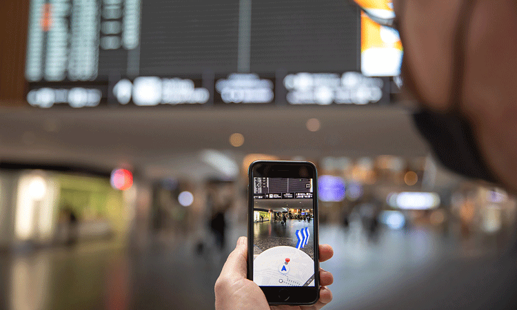
Credit: Zurich Airport (ZRH) uses Google Maps Indoor Live View, making it easier for passengers and visitors to navigate their way around the airport terminals.
The final challenge is probably the worst. What if you can’t read the signage or maps and can’t speak the language? In short, you will be navigating via pictograms, and maybe someone will help you, but it’s far from a good experience.
Goal: Redefining wayfinding at Zurich Airport
So how should wayfinding feel at Zurich Airport? We want it to feel as if you have someone at your side who knows the airport inside out, helping you along your journey. Making sure you find what you are looking for, not only reducing stress so you know how long it will take you to get from A to B, but also making your stay as enjoyable as possible, as now you have enough time to explore.
From the get-go of this exciting project, we were convinced that utilising AR would be a gamechanger to achieve our goal and vision”
Our common vision: Full travel transparency from home to gate
As luck would have it, back in 2018 we had the chance to sit down with members of the Google Maps, Street View and augmented reality (AR) teams under the lead of Petra Ehmann in Zurich, to discuss challenges for which a partnership would be beneficial. So, we brought up the topic of wayfinding and started brainstorming. After a couple of meetings, we penned out our common vision to have full travel transparency for our travellers from home to gate – a bold and ambitious vision that kicked off a lighthouse project between the two companies.
AR as the top technology to achieve our vision and goals
From the get-go of this exciting project, we were convinced that utilising AR would be a game changer to achieve our goal and vision. Augmented reality basically means superimposing digital information onto the real world. There has been a lot of buzz about AR applications lately, but the technology was invented back in the late 60s and has been used e.g., in fighter jets for head up displays, for decades now.
In the case of our lighthouse project the task at hand was to add AR to Google Maps, which would allow the user to tilt their smartphone up, automatically activating the camera and superimposing navigation guidance onto the camera’s live feed.
Credit: Zurich Airport
From a technical perspective, the challenges were aplenty for Google’s AR specialists under the lead of Eric Lai, as the user’s smartphone needs to identify the exact position and heading in real-time to accurately navigate. As GPS is not reliable to triangulate inside buildings, Google’s Street View team collected a vast amount of data using Google’s 360° camera backpacks to create a digital twin of the public airport area, which would become the reference model for Google Indoor Live View to work.
As soon as you start Google Maps Indoor Live View on your phone, the camera live feed is analysed and checked against the reference index containing millions of data points, in milliseconds to provide a lag-free and accurate estimation of your position. This is an incredible achievement as the camera live feed will never be a one-to-one match with the reference data due to ever changing situations e.g., ambient lighting conditions, number of people in the building, and random pop-up stores.
After three years of data capturing, development and testing, Google Maps Indoor Live View was officially launched at Zurich Airport on 1 October 2021, making it very easy for our passengers to find their way.
Google Maps Indoor Live View is an end-to-end AR navigation feature built into Google Maps. The integration into Google Maps was pivotal and ensured reach, which would not be possible with any other application on the market as it is the most used smartphone app in the world.
Google’s Street View team collected a vast amount of data using Google’s 360° camera backpacks to create a digital twin of the public airport area, which would become the reference model for Google Indoor Live View to work”
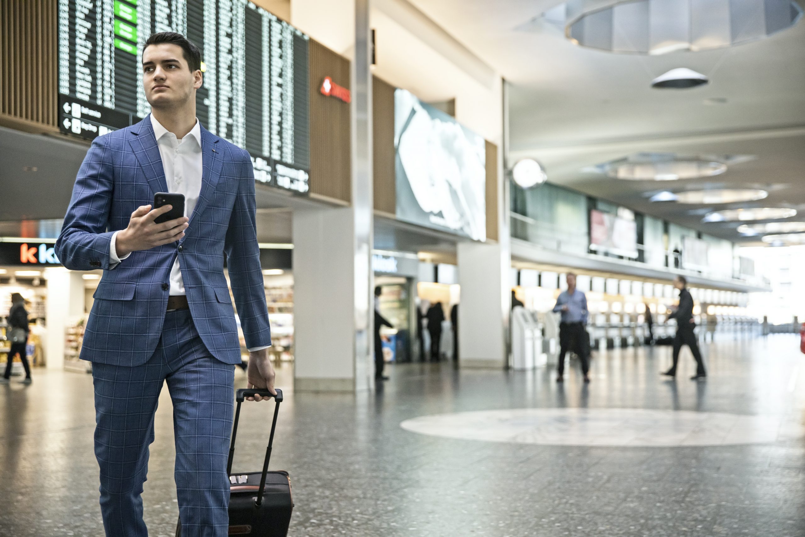
Let’s make a full circle back to the travel story at the beginning of this article. A long-haul traveller just arrived at Zurich Airport for the first time and wants to check directions and the time it will take to reach the baggage hall. Our traveller opens Google Maps, types in the location of interest in the search bar, tilts the phone and instantly receives directions in AR and the time to the destination in his preferred language.
Wayfinding has never been easier and more fun, so make sure to check it out next time you are at Zurich Airport.
Biography
 Mark Schwarz is heading digitalisation and business excellence at Noida International Airport, which is owned by Flughafen Zürich AG. Previously, Schwarz led Flughafen Zürich to become the world’s first Google Indoor Live View enabled airport, as well as numerous projects as a Senior Manager for Innovation and New Business. Prior to his position at Zurich Airport, Schwarz founded two start-ups and worked in senior positions in the financial industry.
Issue
Related topics
Airport development, Augmented reality (AR)/ Virtual reality (VR), Digital transformation, New technologies, Passenger experience and seamless travel, Terminal operations


 Chief Executive Officer
 CEO
CEO Chief Operating Officer
 Head of Operations, Safety and Emergency
 Chief Strategy Development Officer
 Head of Operations
 Airport General Manager
 CEO
CEO Chief Executive Officer