

GIS software: A strategic tool for planning, passengers and retail
- Like
- Digg
- Del
- Tumblr
- VKontakte
- Buffer
- Love This
- Odnoklassniki
- Meneame
- Blogger
- Amazon
- Yahoo Mail
- Gmail
- AOL
- Newsvine
- HackerNews
- Evernote
- MySpace
- Mail.ru
- Viadeo
- Line
- Comments
- Yummly
- SMS
- Viber
- Telegram
- Subscribe
- Skype
- Facebook Messenger
- Kakao
- LiveJournal
- Yammer
- Edgar
- Fintel
- Mix
- Instapaper
- Copy Link
Posted: 21 January 2014 | Vickie Withnell | No comments yet
Vickie Withnell, Group GIS Advisor at Manchester Airports Group, explains how GIS software has become a strategic tool, helping with a range of complex issues relating to planning, passengers, retail and the environment.

Overlaying different types of information on the same map gives airports a better understanding of events. Geographic Information Systems (GIS) are often used in this way for airport planning but, at Manchester Airports Group (MAG), the technology is being applied in multiple ways to drive maximum benefit and deliver value across all four of MAG’s airports (Manchester, London Stansted, East Midlands and Bournemouth).
The use of GIS technology at MAG has come a long way. Much of what we do involves spatial information of some type, including operational, asset, retail, demographic and environmental data, so it makes sense to analyse and communicate this around the business using powerful, interactive maps.
As the largest UK-owned airport business, MAG serves around 42 million passengers every year and supports more than 130,000 jobs. We first used GIS at Manchester Airport 20 years ago to count the number of properties inside noise contours; this soon developed into a system to manage noise insulation schemes in the surrounding area. Our community relations team used the technology to examine flight paths, noise contours and residential areas, to identify properties that qualified for funding for secondary double glazing, under the Sound Insulation Grant Scheme. A positive exercise in community relations, it resulted in over 2,000 grants being awarded to local people.
Following this early success, the use of Esri UK’s GIS has steadily expanded. From helping with environmental mitigation to planning development strategies, GIS has helped support many complex business decisions.
Developments in the technology have helped support this transition, including analytical processes which have become more advanced and deliver new levels of insight. Previously, simple angular shapes on maps were used to define areas of use or interest. Now we use sophisticated analytical tools, to model ‘what if?’ scenarios or produce drive times, when analysing transport provision, for example. The technology is also far more easily available with GIS now accessible by a variety of mobile applications, on a multitude of mobile devices.
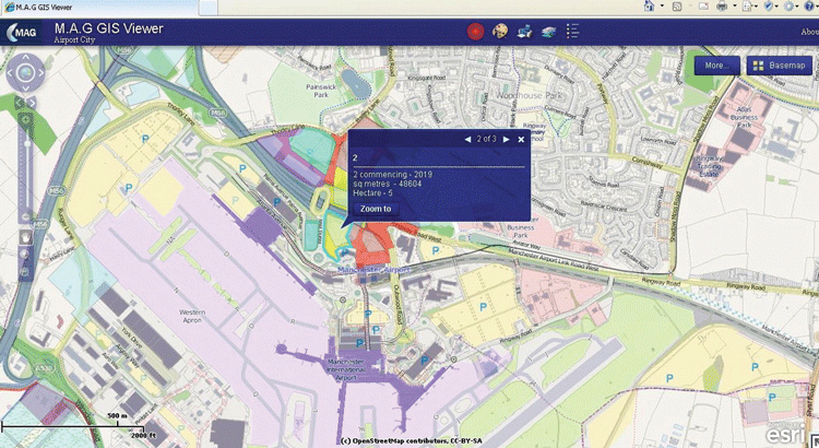
Screen shot of the Airport City web app
Benefits to date
One of the primary ways GIS has helped Manchester Airport grow is by giving clarity to complex operational, environmental and strategic issues, which has helped us to make decisions about its ongoing development.
GIS is critical when it comes to planning and development as it enables us to examine all the relevant factors in one common operational picture. It allows us to model the commercial, ecological and operational impact of any developments or new infrastructure, taking into account planning constraints too. The planning team can model multiple ‘what if?’ scenarios and make plans that are based on facts, not conjecture.
Being able to examine operations geographically in this way has resulted in an increasing number of other benefits in recent years. We always knew there was vast potential in GIS, and it was by keeping an open mind and being flexible in our approach, that has helped identify and open up new possibilities for its application across the organisation.
In terms of the customer experience, GIS helped plan the best location of check-in desks to facilitate passenger flow to security gates, to make increased passenger numbers manageable. The sooner passengers can get through security to airside, the greater their likely retail spend, which is critical for our all-important retail partners.
GIS gives us the insight to work effectively with the Greater Manchester Passenger Transport Executive, to plan appropriate services and meet our goal of increasing the number of journeys made using public transport. The passenger journey to and from the airport has been optimised by layering passenger demographic data over a local transport infrastructure map. We have therefore been able to take a strategic planning view, ensuring that the times of transport services fit in with both passenger movements and our staff travel patterns. Likewise, the software helps understand the best location for car parks.
Geographic information was also essential when deciding which passengers and potential travellers we should target in marketing campaigns relating to travel services, such as highlighting the nearest stations for rail passengers or the most convenient car parks for car users. This helped marketing campaigns become more focused and reduce wastage.
During the renovation of departure areas, Manchester Airport also put GIS to work by modelling new retail areas to make best use of space. Demonstrating footfall with GIS helped market units reach the right retailers which ensured that retail revenues were optimised.
In terms of the environment, mapping has been invaluable in determining land use for Manchester’s 350 acres of natural habitat, to comply with environmental controls. We also use the software to demonstrate good corporate citizenship to local communities via easy-to-understand maps and charts.
The value of GIS is also being felt in the maintenance department where it supports the efficient use of resources. Engineers use a mobile app to log faults on a map and request maintenance work while working out on-site. We then analyse all of this data to plan work strategically, taking into account aircraft departure and arrival times. We can now schedule work to suit the business and minimise disruption to our airline customers at busy times.
We also managed to cut down driving and walking time for staff at Manchester, by examining the relationship between our assets and the people who use them throughout their working day. This enabled us to relocate teams to more convenient areas so they would spend less time travelling to and from jobs. At the same time, we managed to free up office space that could be allocated to commercial usage, thereby improving our profitability.
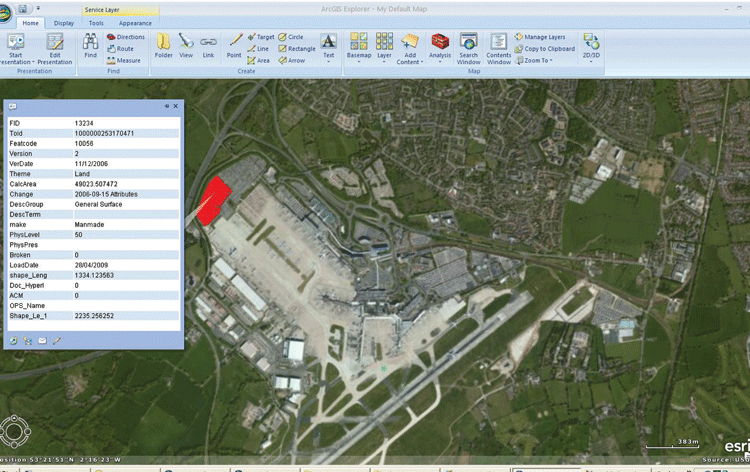
Screen shot of GIS in action
Spreading GIS across the Group
The next phase of GIS development, due to go live in 2014, has been designed to optimise long-term asset planning and help manage the Group’s growth plans. The new system will allow each of MAG’s airports to map and record asset information in one central database and share it between departments.
A major business benefit will be improved collaboration between master planning, asset management, finance, property and engineering, among others, as they’ll be sharing the same central source of asset data. More detailed site data is also being introduced combined with catchment area data, so we will be able to visually manage the assets at each airport, influencing both development and operational needs.
The main value of using GIS for asset management is the powerful combination of spatial and tabular data, which lets us understand things more quickly. Not only can we accurately record the location of assets but also link any essential data to each asset using tables or URLs.
By having a single pool of asset information that informs the whole business, each airport will become better connected internally and be able to make faster operational decisions relating to asset condition, repairs, replacements, funding and investment. This also eliminates the duplication of data and the potential for errors. A set of automated processes will also make data updates more efficient and accurate.
Managing diversity
From its simple beginnings, MAG’s use of GIS has evolved into an invaluable tool supporting many areas of the business. By maintaining an open approach to what might be achievable with the technology, it has permeated into several new areas and this is well illustrated by the latest asset management project. By improving the quality of asset data and making it easier to share, we will be able to harness its true business value over the coming the years.
GIS gives us the big picture needed to manage each airport’s increasing diversity. Overall, it is helping us make sense of complex operational demands and understand any possible conflicts so the right decisions can be made.
 Vickie Withnell is Group GIS Advisor at Manchester Airports Group. Responsible for the ongoing development of GIS across the Group, Vickie has been at MAG for 14 years. She started her career at MAG in Security Operations before moving to a role involving GIS within Planning and Asset Management.


 Chief Executive Officer
 CEO
CEO Chief Operating Officer
 Head of Operations, Safety and Emergency
 Chief Strategy Development Officer
 Head of Operations
 Airport General Manager
 CEO
CEO Chief Executive Officer