

Advancing technologies in winter weather forecasting
- Like
- Digg
- Del
- Tumblr
- VKontakte
- Buffer
- Love This
- Odnoklassniki
- Meneame
- Blogger
- Amazon
- Yahoo Mail
- Gmail
- AOL
- Newsvine
- HackerNews
- Evernote
- MySpace
- Mail.ru
- Viadeo
- Line
- Comments
- Yummly
- SMS
- Viber
- Telegram
- Subscribe
- Skype
- Facebook Messenger
- Kakao
- LiveJournal
- Yammer
- Edgar
- Fintel
- Mix
- Instapaper
- Copy Link
Posted: 23 February 2017 | Jaakko Nuottokari | General Manager of the Northern Europe Aviation Meteorology Consortium (NAMCON) | No comments yet
General Manager of the Northern Europe Aviation Meteorology Consortium (NAMCON), Jaakko Nuottokari, discusses the challenges and obstacles involved in the efficient running of an airport in adverse weather and examines the new technologies in place to help with advanced forecasting.
Drawing from the climatology of Northern Europe and the specific challenges it poses on aviation, the Northern European National Meteorological Services (NMS) has developed specific expertise on observing and forecasting winter weather.

We experience winter conditions for more than six months in a year and the daily lives of citizens depends on the roads being cleared of snow and ice, trains running on time, ships running on schedule and aviation functioning even in adverse winter weather. The Northern Europe Aviation Meteorology Consortium (NAMCON) – a cooperation between the National Meteorological Services of Denmark, Estonia, Finland, Iceland, Latvia, Norway and Sweden – emerged from an increasing pressure on the NMSs as designated MET service providers to air navigation to at the same time increase efficiency, harmonise production, innovate and develop new services for emerging user applications.
The task is for one small – to medium-sized NMS a great challenge, and a grouping of seven NMSs can pool together the resources and expertise to meet these challenges much better. The long history of cooperation in Numerical Weather Prediction (NWP), weather radar and training combined with the strong organisational will to create the NAMCON consortium has been and remains the backbone of the cooperation.
The main goal of the consortium is to reduce the cost of designated aviation weather services in line with the Single European Sky Reference Period 2 targets and beyond. The main tool to achieve this is to join the production of services and products and reduce overlap. Examples of such initiatives are the cross-border TAF production over Southern Sweden by the Danish Meteorological Institute and the joint production of the Nordic Significant Weather Chart (NSWC) by the Swedish Meteorological and Hydrological Institute (SMHI) and Finnish Meteorological Institute (FMI).
Information management and production methods are also streamlined into a joint MET briefing portal. NAMCON aims to set the stage for regional service delivery of aviation weather services in Northern Europe by harmonising production and creating joint initiatives. Through incremental and systematic development and cooperation, the challenges of future service delivery can be met while ensuring the continuity of most operations.
Freezing precipitation
The transition from liquid to solid precipitation and back can happen quickly and involves many precipitation states, from ice particles within the cloud to snow or a mixture of snow and water or plain water. Regular rain can fall in conditions where the surface temperature is below freezing and thus forms glaze over surfaces, resulting in either freezing rain or freezing drizzle. In order to assist airports and airlines in their operations in these conditions, the different precipitation types must be identified and their processes transformed into forecast algorithms.
Such algorithms are being developed in an operational setting by a group of specialised forecasters. An example of an operational product to forecast precipitation type is given in Figure 1. Precipitation type is estimated using the model parameters at model surface levels (typically around 65 vertical levels) to identify the patterns typically leading to the formation of such phenomena. This requires solid forecasting experience and deep theoretical background from the meteorologists. The precipitation type forecast tools allow the user to have an advanced warning about the onset and cessation of events such as heavy snowfall or freezing rain, potentially causing major impacts to airport operations especially.
The precipitation type forecasts are available depending on the initial model up to 15 days in advance. However, the best accuracy is achieved with limited area models with forecast times less than five days. As part of the TOPLINK project, the FMI developed also a multi-model probabilistic precipitation type product based on the locally run HIRLAM, European ECMWF and U.S. GFS models. This tool is a pre-planning tool to identify winter weather risk well in advance at European major airports and will undergo operational trials during 2016 and ready for deployment in 2017-18 as part of SESAR solutions.
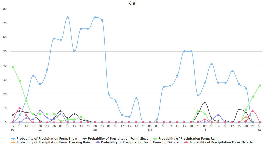
Figure 1: Five-day multi-model probability forecast of rain, snow, sleet, freezing rain, freezing drizzle or drizzle for Kiel on 15 January 2016
Poor visibility and low cloud base
NWP models produce many different post-processed visibility and cloud base products. Many of these have been performing poorly, and thus operational aviation weather forecasters have developed new post-processing methods to improve forecast accuracy. The developed methods are tested, monitored and verified against observations with special attention on the correct geographical and temporal representation of the phenomena. The developed algorithms make use of the vertical levels closest to the ground and thus are not only based on surface condition forecasts.
Airport decision making support tools
Runway clearing Even a minor snowfall can significantly impact airports’ operations if the appropriate measures are not planned for and executed in a timely and efficient manner. Meteorological considerations play a vital role in every phase of the planning effort that has to be made in order to be prepared for a snowfall event.
Strategic planning
Almost every major airport (at least in Europe) needs to undertake a risk analysis for the likelihood of having an interruptive snowfall event. A climatological survey will give an overview on the frequency of such events in the past. This will also serve as a good indication on the possibility of future events, however different scenarios covering the effects of global warming should also be investigated. NAMCON and its member NMSs have the capability to support the regional national authorities and decision makers with winter weather frequency prognosis based on historical data and global climate models covering the rest of this century.
Once a realistic possibility of future snowfall events has been established, the airport management needs to run a cost/benefit analysis. In areas with low probability of snow, one can save a considerable amount of money by not investing in the purchase and maintenance of snow clearing equipment, but then one must be willing to accept that a rare snowfall incident could close down airport operations completely until warmer weather clears the snow the natural way. In areas that are more exposed to winter weather, airport administrations cannot risk the consequences associated with snow closing down the airport for longer periods of time and must therefore invest and plan to achieve sufficient snow clearing capabilities.
In the week before a possible snowfall event, more emphasis must be put on manpower dispositions. It is of no use to have a lot of expensive snow clearing vehicles if you don’t have the staff to operate them or enough ice melting chemicals available. NAMCON offers an increasing range of probabilistic forecast products that could be utilised much better than they are today. In most cases they perform better than the regular deterministic forecasts, giving more suitable information to the decision makers on when a costly snow clearing readiness should be maintained.
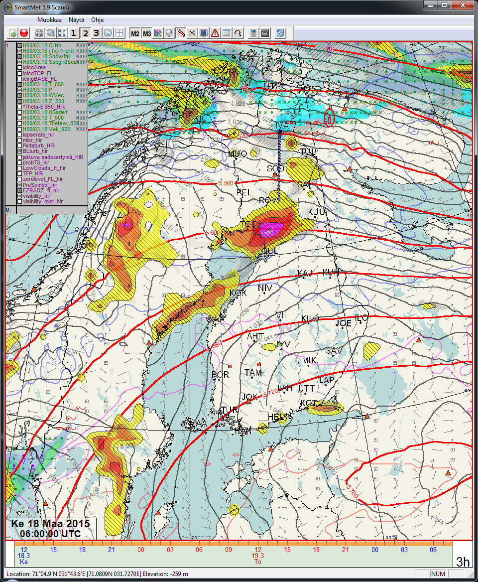
Figure 2: Output from the visibility algorithm drawing from the HIRLAM limited area NWP model case from 18 March 2015 with a poor visibility area over the Bay of Bothnia between Finland and Sweden extending eastward over Finland
Operational planning
As the snow starts to fall the real work for the ground crew begins. There is a delicate balance in when to perform snow clearing activities and when to close or open runways. If the snowfall prevails after clearing the runway, it might need to be cleared again. Ice melting chemicals must be applied at the right moment and of the right sort to have maximum effect. Dry snow can more easily be blown or brushed away, but if it gets wet, it must be removed before it turns into ice. The NAMCON community has developed several meteorological nowcasting techniques to provide more accurate decision supporting tools to the runway management units. Weather-radar extrapolation provides reliable information on the start and stop of the snowfall. Combined with fine scale numerical forecasting models, it provides very accurate information on precipitation intensity and type.
Reduced runway friction
A regular passenger airplane weighs more than 60 tonnes and has a speed of approximately 300km/h when it comes in for landing. Accurate knowledge of the runway friction is essential to perform a safe landing. The most common way to assess the runway friction is to drive a car at high speed along the runway. Based on the car’s handling, or friction measurements taken from the car, you get an impression of the braking conditions. The problem with this approach is that an airplane can experience quite different conditions than what you measure from a car. Another problem is that a friction measurement is only valid at the time it is taken. Ten minutes later, conditions can have changed quite drastically.
The precipitation type forecast FIGURE 3 tools allow the user to have an advanced warning about the onset and cessation of events such as heavy snowfall or freezing rain, potentially causing major impacts to airport operations especially.
To help the ground crew maintain a correct and continuous overview of the friction conditions, collaborative decision making (CDM) tools have been developed in the NAMCON area. In such systems information from sensors in the runway showing temperature, humidity, snow or ice cover is combined with manual or semiautomatic runway reports and input from the ongoing snow clearing and friction improving actions. Such algorithms produce a continuous assessment of braking conditions with a cross reference to the latest friction measurements and pilot reports. This will also build a historical database that will help the system improve accuracy over time.
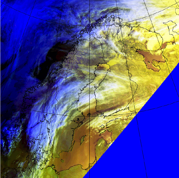
Figure 3: High-resolution weather satellite image from 18 March 2015. Low visibility is associated with the low cloud and/or fog represented with the areas of yellow colour
Crosswind
The crosswind component can together with reduced runway friction give large constraints to airport throughput, especially in connection with short-final and landing procedures. NAMCON members can provide and further develop techniques based on ultra-fine-scale nested modelling that can give very high-resolution wind information for every part of the airport, including the approach and touchdown zones. These techniques have already shown good results in forecasting problematic turbulence areas at a number of Norwegian airports.
De-icing operations
The SESAR1 industrial research programme included a number of meteorological service innovations that were trialled in an operational setting. For Northern Europe, a solution to support de-icing operations was developed and trialled at Oslo airport. The SESAR de-icing operation support forecast provides a forecast of de-icing requirement class, thus giving information on the potential impact to de-icing operations at the airport. The solution builds upon an innovative method using weather radar information and motion vectors to accurately predict the onset, duration and cessation of conditions leading to a de-icing requirement in the short term.
Convective precipitation at coastal aerodromes
The formation of heavy showers of snow over sea is an occasionally occurring significant weather phenomenon in northern latitudes. With cold air being adverted over relatively warm water, the moisture of the sea will rise and showers of snow will form in bands in the prevailing wind direction. The bands of showers will reach about 100-150km over land before they dissipate due to lack of moisture from the cold ground. If the wind persists in the same direction the showers can stay in the same place for hours and even days causing massive snowfall. This phenomenon is very well known for example along the costs of the Baltic Sea, along the Norwegian coast and on the southern shores of the great lakes in USA.
The weather forecasting models of today are in general very good at predicting precipitation and thus it is not as much a matter of forecasting the occurrence of showers as a problem of prediction the exact location. Since these bands can be quite narrow, we will experience that one place will get a great amount of snow while there will be nothing just a few kilometres away. That kind of accuracy in the models is not possible to achieve today. What we will get is a YES or NO in the forecast, which in these cases is very much misleading.
To get an accurate forecast for aerodromes affected by local showers of snow we must use probability forecasts which are much closer to the “truth” than the deterministic output of a NWP. Within NAMCON there is a great effort underway to be able to present forecasts as probabilities, using multiple models to get the most likely output as well as the probability of other outputs. Instead of a NO you might get that the probability of heavy showers of snow is 40%, which could be considered a great risk. For any aerodrome a heavy snowfall may cause severe loss of capacity and a more truthful forecast may give the aerodrome administration a god chance to prepare. When the actual snowfall occurs it must be monitored closely since the reality might not be in line with the forecast. A small change of wind direction could quickly change the location of the showers. Access to real time radar images and essential and a close relation to the local forecaster can be of great help.

Jaakko Nuottokari is the General Manager of the Northern Europe Aviation Meteorology Consortium (NAMCON), a research scientist in numerical applications for aeronautical meteorology based in the Finnish Meteorological Institute. Mr Nuottokari is the FMI coordinator for the SESAR Large Scale Demonstration project “TOPLINK” and the project manager for the SESAR Deployment project “SWIM MET deployment to support NEFRA”. Mr Nuottokari holds a M.Sc. in meteorology from the University of Helsinki and has a background as an aviation weather forecaster.


 Chief Executive Officer
 CEO
CEO Chief Operating Officer
 Head of Operations, Safety and Emergency
 Chief Strategy Development Officer
 Head of Operations
 Airport General Manager
 CEO
CEO Chief Executive Officer