

Winter operations – Developing weather forecast capabilities
- Like
- Digg
- Del
- Tumblr
- VKontakte
- Buffer
- Love This
- Odnoklassniki
- Meneame
- Blogger
- Amazon
- Yahoo Mail
- Gmail
- AOL
- Newsvine
- HackerNews
- Evernote
- MySpace
- Mail.ru
- Viadeo
- Line
- Comments
- Yummly
- SMS
- Viber
- Telegram
- Subscribe
- Skype
- Facebook Messenger
- Kakao
- LiveJournal
- Yammer
- Edgar
- Fintel
- Mix
- Instapaper
- Copy Link
Posted: 13 January 2017 | Jon Dutton | No comments yet
Jon Dutton, Met Office Aviation Business Manager explores how developments in forecasting capability combined with a detailed understanding of airport challenges and operations enables confident decision making in the lead up to, and during, high-impact weather events.

Over the last few years winters in the UK have been relatively mild, minus a few exceptions, the winter of 2010 being a clear example with all parts of the UK experiencing extensive snowfall and disruption to travel networks.
However, this seemingly mild trend with occasional cold periods adds a challenge to airport winter preparedness – how can airports plan effectively around this apparent chaotic behaviour of our weather and, as I explore in this article, what is the Met Office doing to try and help?
There are two main ways in which weather forecasters can help winter preparedness: an improved forecasting capability from seasonal through to tactical decision making time frames; and a better integration of weather forecasting capability into airport decision making.
Improving forecast capability
It is widely known that there is a degree of uncertainty in weather forecasts, and that the weather in the UK is particularly variable and localised (or has its own ‘micro-climate’).
With regards to uncertainties, whilst the UK has a relatively dense network of weather observations, we can’t measure everything everywhere, such as large areas of ocean. For this reason, we can never have a perfect understanding of the atmosphere now, so how can we hope to provide a 100 per cent accurate forecast for one hour or one year ahead?
As for the second point regarding micro-climates, the UK is a relatively small island located between continental Europe and the Atlantic Ocean, but has a vast range of topography and land uses. These all have a big influence on the local weather so how can we accurately reflect all of this in a weather forecast process?
Along with other leading weather forecasting centres around the world, our approach is to tackle these problems by running weather models at ever finer resolutions and several times with slightly different starting conditions to understand the uncertainty in a weather situation.
To help explain what we mean by this, let’s look at what we mean by resolution. If you imagine the whole world covered in a square grid pattern, we effectively run mathematical equations at each of those grid points to ‘move’ the weather situation forward in time. Every time we increase the resolution by a factor of one, we increase the number of grid points by four meaning that many more calculations are needed in the weather forecasting process.
Other developments include running our weather models several times; known as ‘ensemble’ forecasting. The idea of this is that by running the model several times and slightly changing the starting conditions each time, we can better understand the range of weather scenarios that develop in the forecast evolution. Whilst there will always be uncertainty within a weather forecast – this approach enables us to quantify that level of uncertainty.
Advancing supercomputing – help and hindrance
The two approaches of improving forecast capability by increasing resolution and running the forecast models several times both require a significant increase in computing power. To answer this challenge, in 2014 the Met Office announced a UK government investment of £97 million in a new supercomputer. At 13 times more powerful than its predecessor, the new Cray supercomputer is now operational and ranked as the top high performance computer in Europe, delivering more than 16 trillion calculations per second.
There is a risk that more powerful computers, though they enable more detailed forecasts, could also create more inaccuracies. To mitigate this, the additional computing power needs to be combined with more advanced atmospheric science to feed into the process. So, what have these combined activities provided? The Met Office Global Model now has an increased horizontal resolution of 17KM and we plan to upgrade to 10KM in the summer of 2017. In the UK, our operational model runs at 1.5KM and we are also running a research project to assess a 300M model over parts of the UK. This is a massive increase in the number of grid points and we’ve also increased the number vertical levels from 70 to 140.
In addition, the Met Office is running an ensemble model to cover the whole globe at a resolution of 33KM plus a UK ensemble at 2.2KM resolution.
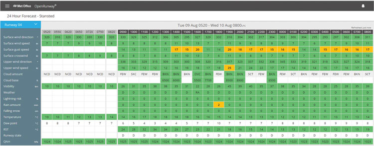
An example of an OpenRunway® 24-hour forecast using RAG (red, amber, green) statuses
Integrating the forecast with decision making
Perhaps a more important question is what does all this mean in terms of improving weather forecasts and enabling winter preparedness at airports and throughout the aviation industry?
The higher resolution models allow us to more finely model the behaviour of the atmosphere including small scale processes such as the heat transfer near to the surface and the small-scale wind flow in and around airports, or even a better representation of the variety of particle sizes that make up the dust that exist in the atmosphere. These fine-scale features all are important contributors to better understanding and predicting the risks of frost, ice, fog and snow at airports. This information can then be represented in the forecast information we provide to the industry such as OpenRunway® or in discussion with our forecasting team.
Despite the above investments and developments, the atmosphere remains a chaotic system. For this reason, there will always be uncertainty associated with a weather forecast. The second part of this discussion is therefore perhaps more important than the advances in forecasting; that is, how do we better integrate weather forecasting capability?
The way an airport operation can be impacted by weather often includes a complex mix of non-weather factors such as size, capacity, demand, and staff availability. In the case of de-icing or snow, this extends to equipment availability. As these factors are different for each airport, it is likely that adverse weather planning is individual to each airport environment and operational set-up. In order to ensure that the best (or most relevant) MET-information is provided to an airport, it is vital to understand such specific airport operational processes.
This can often involve a conversation about realistic forecasting capability and what is therefore viable for an airport to expect in terms of accuracy and timeliness of information. By combining a realistic MET-capability and an understanding of the airport operation, it is possible to jointly develop severe weather plans that are both relevant and achievable.
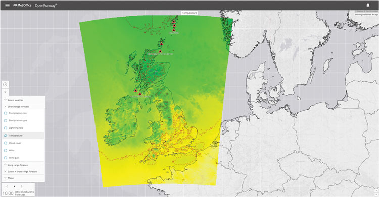
Map view of OpenRunway®
Developing a snow plan
In the case of developing a snow plan, it is very unlikely that any weather forecasting organisation can provide an accurate snow forecast to the nearest cm several days ahead of a snow-fall event. However, at 48 hours notice, it would certainly be viable to provide forecasts in useable ranges and, perhaps 12- 24 hours ahead, a detailed forecast to the nearest cm. Therefore, if additional staff are to be pre-warned or put on stand-by, 48 hours notice of a snow event could align well with forecast capabilities. Given the increasing capabilities provided by the ensemble modelling approach, there is now a far greater amount of information available to describe and quantify the likelihood of an event and therefore enable an airport operations team to manage the risk of disruption vs. the costs of standing up teams.
Updates can then be provided as a snow event approaches by the forecasting team. They utilise the high resolution and ensemble modelling capabilities to provide more detailed advice, both in terms of intensity of snow and timing. This enables tweaking of the airport’s response, whether it is related to runway clearance or the management of passengers within the terminals.
Seasonal forecasts for longer-term planning
A further example is to think about much longer timescales, specifically seasonal forecasting. This is an area where there is potentially real value for an airport or an airline operation; if a weather forecast provider can provide accurate information on the likely nature of a winter season, it may then be possible or an airport or airline to consider the appropriate level of de-icing preparedness.
The seasonal timescale is an area where the Met Office has dedicated a large amount of effort in understanding how to provide meaningful and reliable information. There are many global circulations which have an impact on the weather in a location such as an airport in the UK. For example, you may have come across El Niño or the North Atlantic Oscillation, but you may not have heard of the Quasi-biennial1 or Maden-Julian Oscillations2. However, from the forces driving the intensity and location of thunderstorms in the tropics, to the more local variations in sea temperature in the North Atlantic – these are all important determining factors in the weather likely at regional or airport level.
At the Met Office, it is exactly the same atmospheric physics which is used in our forecasting processes, whether we’re looking at one hour or three months ahead. The difference in the seasonal timescale is the reliability in the detail and, given the large range of factors involved, it is likely that a seasonal forecast will always be more about the likely trends in the evolution of the weather rather than specifics. However, the last few winters have seen good skill in the seasonal predictions.
Perhaps the challenge now is to jointly develop the use of this increasing confidence in seasonal timescales – into ways which enable even better winter preparedness within airlines and airports – for the years to come.
References
- The Quasi-Biennial Oscillation is a regular variation of the winds that blow high above the equator. Strong winds in the stratosphere travel in a belt around the planet, and every 14 months or so, these winds completely change direction. This means a full cycle takes roughly 28 months, making it the most regular slow variation in the atmosphere after the cycle of the seasons.
- The Maden-Julian Oscillations is an intra-seasonal mode and is sometimes referred to as the 30-50-day oscillation. It is characterised by an eastward moving disturbance of very vigorous convection that originates over the Indian Ocean and then moves over Indonesia into the west Pacific. It is somewhat erratic in its nature, and often disappears completely for several months before re-emerging.
OpenRunway®
OpenRunway® is an online weather forecasting package that helps airport and airline operators make confident weather-sensitive decisions, helping flights run to schedule and ensuring the safety of passengers. As well as advising when runways require treatment to weather conditions breaching thresholds set by the user, it also advises when they can stay open during marginal weather situations, helping to save costs and minimise disruption to passengers, airlines and airports.
OpenRunway® alerts those who need to know the current and forthcoming weather conditions at an airport up to 10 days in advance, allowing all-important lead time to plan ahead and minimise disruption. This in turn helps reduce unnecessary runway closure and other costs, whilst maximising operational efficiency and safety.
The enhanced version of the product – launched last year offers:
- Responsive design – access to information via mobile and tablet devices
- 24 hour forecast information
- Observations data
- Tabular and map data displays
- Meteorologist consultancy services 24/7
- Forecast outlook (0-5 day PDF and 6-10 day PDF)
- Data update notification
- 24/7 technical support
- Ability to set bespoke thresholds
- Improved mapping and weather layer information
- Easier administration
- Five-day aircraft de-icing outlook
- Map visualisation of aerodrome warnings in the UK
- Screen configured for optimum wide screen visualisation.
For more information and to view a video on OpenRunway® visit: www.metoffice.gov.uk/aviation/OpenRunway
Biography
Jon Dutton has worked for the Met Office for 14 years, initially joining as a senior aviation forecaster, focusing on civil aviation services. Jon then moved in to operations management, ensuring the effective delivery of meteorological services to customers in a variety of transport related industries and currently he is Business Manager of the Met Office Aviation team. Prior to the Met Office, Jon spent two years working for the Environment Agency, and he has a master’s degree in Applied Meteorology from the University of Reading.
Issue
Related topics
Meteorology, Regulation and Legislation, Runways and pavements, Terminal operations, Winter operations


 Chief Executive Officer
 CEO
CEO Chief Operating Officer
 Head of Operations, Safety and Emergency
 Chief Strategy Development Officer
 Head of Operations
 Airport General Manager
 CEO
CEO Chief Executive Officer