

Airfield Safety: Automated obstacle control
- Like
- Digg
- Del
- Tumblr
- VKontakte
- Buffer
- Love This
- Odnoklassniki
- Meneame
- Blogger
- Amazon
- Yahoo Mail
- Gmail
- AOL
- Newsvine
- HackerNews
- Evernote
- MySpace
- Mail.ru
- Viadeo
- Line
- Comments
- Yummly
- SMS
- Viber
- Telegram
- Subscribe
- Skype
- Facebook Messenger
- Kakao
- LiveJournal
- Yammer
- Edgar
- Fintel
- Mix
- Instapaper
- Copy Link
Posted: 19 December 2013 | Seong-Kag Hong, Vice President, Aerodrome Division at Incheon International Airport Corporation. | No comments yet
Incheon International Airport uses an automated airport obstacle control system to maintain a safe airfield. Seong-Kag Hong, Vice President for Incheon’s Aerodrome Division provides an overview of the system…

Figure 1: Current Incheon Airport OCS 2013
Incheon International Airport uses an automated airport obstacle control system to maintain a safe airfield. Seong-Kag Hong, Vice President for Incheon’s Aerodrome Division provides an overview of the system…
Obstacle control surfaces (OCS) are defined in airspace around airports and maintained free from obstacles to enable intended aircraft to manoeuvre safely and prevent airports from becoming unusable by the growth of obstacles. ‘Obstacles’ can include both temporary and permanent mobile objects and parts thereof which penetrate the OCS. They are managed by airport operators.
Incheon Airport is operated by Incheon International Airport Corporation (IIAC), a government-owned corporation. IIAC took over legal responsibly for controlling obstacles at and in the vicinity of Incheon Airport from a regional Civil Aviation Authority in 2006.
Incheon Airport obstacle limitation surfaces (OLS) consist of approach, transition, horizontal and conical surfaces established for precision approach runways (see Figure 1). IIAC has initiated a manual obstacle review using a land registration map on a scale of 1-5000 and a 12-inch ruler for the purpose of measuring a perpendicular distance from a centre at the end of a runway strip to an object on the map. An applicable surface’s limited height of the object was calculated in accordance with the definition of each surface’s dimension and slope. More than 400 objects per year were checked with this hand-operated process but it became difficult to secure integrity in the process of data handling and experience was also a problem.
Figure 1: Current Incheon Airport OCS 2013
Areas which required controlling included:
- OCS provision
- A check of objects, whether they penetrate the OCS or not
- Obstacle survey – an on-site inspection
- Negotiation with obstacle owner for obstacle removal or reduction in height.
Establishing a computerised system
In 2009, IIAC made the decision to build an Obstacle Control System based on computerised digital technology.
Terrain and obstacle survey
Initially, terrain and obstacles underlying the Incheon Airport OCS – including ICAO 2, 3 and 4 areas within a 17km radius from the ARP – were surveyed by LiDAR scanning in the air with the exception of small objects inside the airport such as approach lights and localiser antenna. They were surveyed by the total station precise field survey method.
Terrain and obstacle data numerical requirements
Terrain and obstacle data numerical requirements were complied with ICAO Annex 15 Standards and Recommended Practices (see Table 1).
Obstacle data | Area 2 Terrain Data | Area 3 Terrain Data | Area 4 Terrain Data |
Horizontal accuracy | 5.0m | 0.5m | 2.5m |
Data classification integrity level | Essential 1 * 10-5 | Essential 1 * 10-5 | Essential 1 * 10-5 |
Vertical accuracy | 3.0m | 0.5m | 1.0m |
Vertical resolution | 0.1m | 0.01m | 0.1m |
Confidential level | 90% | 90% | 90% |
Electronic terrain data and charts
Data acquired from the survey was converted to Digital Elevation Models, which were 3D representations of terrain surfaces (see Figure 2). Electronic charts for ICAO areas chart were also drawn.

Figure 2: 3D electronic terrain data image
Visualisation of electronic OCS
An attempt to draw three different types of e-OCS was made, which were in compliance with the Korean Aviation act, ICAO and FAA regulations for the comparison of each OCS (see Figure 3).
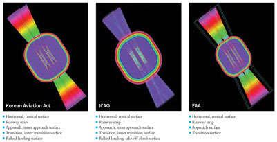
Figure 3: Visualisation of electronic obstacle control surface in compliance with the Korean Aviation Act, ICAO and FAA regulations
Electronic obstacle data identification
All kinds of obstacles penetrating the OCS were identified in profile with their description and height above the data.
Incheon Airport Obstacle Control System
The system established several main functions focused on data management, safety assessment, obstacle chart management and public administration – all based on the data of terrain and obstacles. Additionally, it provided obstacle marking and lighting management and obstacle on-site inspection using mobile equipment (GPS-installed) functions (see Figure 4, page 41).
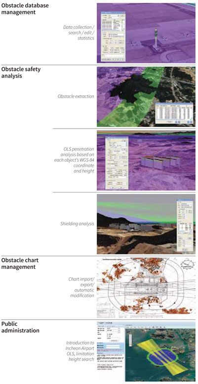
Figure 4: Incheon Airport’s obstacle control system
Upgrading the system
In 2011, Incheon Airport trialed a system upgrade which emphasised the surveying of the obstacle free zone (OFZ) to further develop existing ‘public administration’ functions along with drawing an OLS for the reserved fifth runway at Incheon. The survey of objects in the OFZ had been progressed by ground survey methodology along each runway and parallel taxiway either on foot or by driving. The procedure of data identification and installation at the existing OCS was found to be the same as the results from the initial survey in 2009.
Upgrading the public administration function was mainly improving public service through internet services open to local selfgoverning bodies which had requested reviews of obstacles within their administrative districts to IIAC in person or by telephone or fax – all inconveniently. The main purpose of this improvement was to display the analysis of obstacles via a web page in real-time, thereby reducing the manual obstacle review work between the IIAC and local bodies.
Benefits of using the OCS
The OCS has produced numerous benefits. Analysis time deciding whether an object is penetrating the OLS has reduced from 60 to 10 minutes. Additionally, the secure level of handling data through digital obstacle data management has been improved. Human error has been minimised by conducting a systemised safety analysis. Customer satisfaction has been granted by providing OLS information via a web page while the computerised system has made it more convenient for the operators. And lastly, the standards related to ICAO regulations have been met and maximised.
Future obstacle control
Airport operators should make follow-up surveys periodically to determine the presence of new obstacles. IIAC is planning to conduct the upcoming periodic survey in 2014. The survey is not only aimed at simple obstacle control but for establishing an aerodrome mapping database (AMDB) to comply with both local and international regulations. Precision survey of objects which are compositions of consisting aerodrome map and database establishment will contribute to build up an AMDB optimised to Incheon Airport. It is expected that the AMDB will be used in a wide variety of applications, which is intended primarily to improve situational awareness and to supplement surface navigation, thereby increasing safety margins and operational efficiency.
Biography
Seong-Kag Hong is Vice Presi – dent for the Aerodrome Division at the Incheon International Airport Corporation. Hong has been Director of Information and Communication at IIAC since May 2004. He progressed to Deputy Executive Director for the Air Navigation Group in November 2010, a post he stayed in for two years, before becoming Vice Figure 4: Incheon Airport’s obstacle control system President of the Aerodrome Division in June 2012.


 Chief Executive Officer
 CEO
CEO Chief Operating Officer
 Head of Operations, Safety and Emergency
 Chief Strategy Development Officer
 Head of Operations
 Airport General Manager
 CEO
CEO Chief Executive Officer