

Meteorology: Top notch aviation weather services for Hong Kong
- Like
- Digg
- Del
- Tumblr
- VKontakte
- Buffer
- Love This
- Odnoklassniki
- Meneame
- Blogger
- Amazon
- Yahoo Mail
- Gmail
- AOL
- Newsvine
- HackerNews
- Evernote
- MySpace
- Mail.ru
- Viadeo
- Line
- Comments
- Yummly
- SMS
- Viber
- Telegram
- Subscribe
- Skype
- Facebook Messenger
- Kakao
- LiveJournal
- Yammer
- Edgar
- Fintel
- Mix
- Instapaper
- Copy Link
Posted: 26 January 2016 | Chi-ming Shun and Pak-wai Chan of the Hong Kong Observatory (HKO) | No comments yet
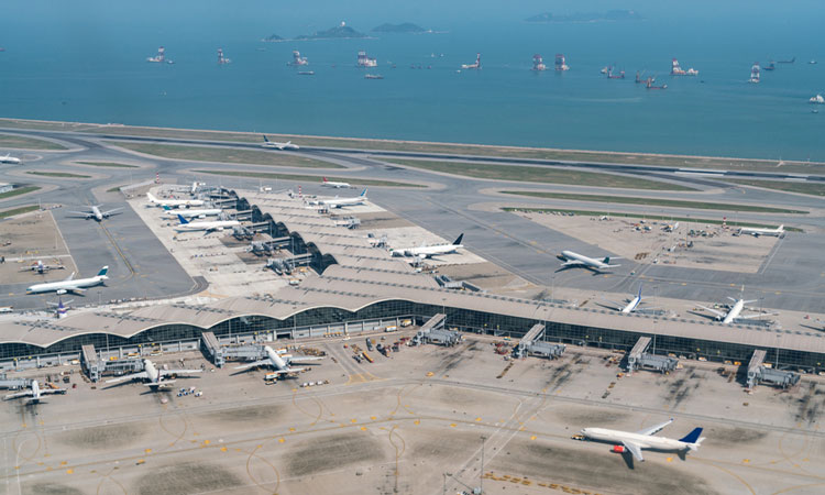
As the third busiest airport in the world, with a passenger throughput of over 63 million in 2014, Hong Kong International Airport (HKIA) faces the challenge of sustaining smooth operations during hostile weather conditions. Chi-ming Shun and Pak-wai Chan of the Hong Kong Observatory (HKO) reveal how in order to meet the needs of the aviation community the HKO provides tailored aviation weather services…
Similar to other busy airports, HKIA faces the challenge of maintaining smooth operations in adverse weather conditions such as thunder – storms, low-level windshear and even tropical cyclones. To combat these challenging conditions, the HKO operates a suite of high-tech meteorological equipment (Figure 1) and provides tailored weather services to improve safety while minimising disruption to airport operations.
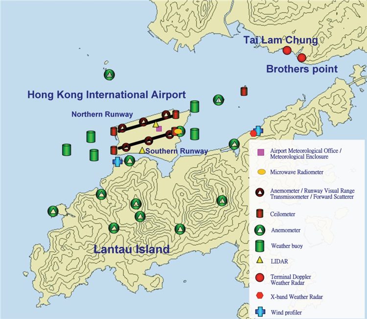
Figure 1: Meteorological equipment operated by HKO for serving HKIA. The complex terrain near the airport is also shown, with height contours every 100m
Cutting-edge technologies
HKIA is situated in a subtropical area where thunder and lightning storms can be very active. Such weather conditions cause significant impact to air traffic within the Hong Kong Flight Information Region as well as ground operations at the aerodrome. The standard aviation weather services prescribed by the International Civil Aviation Organization (ICAO) are insufficient to meet the needs of airport operations and air traffic management (ATM).
To ensure efficiency of ground operations, which naturally have to stop during lightning strikes to protect the ground personnel, HKO has developed the Airport Thunderstorm and Lightning Alerting System (ATLAS) for HKIA. For such a busy airport, every minute counts. ATLAS provides precise forecasts of the location of lightning strikes at the airport down to minutes and enables the Airport Authority of Hong Kong (AAHK) to issue different warning levels, therefore minimising disruption to airport operations (Figure 2a).
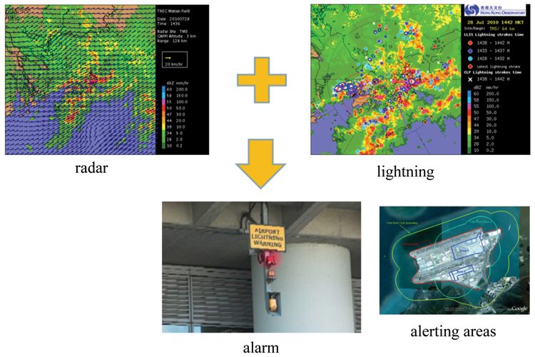
Figure 2a
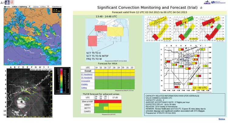
Figure 2b: Two advanced convective weather alerting systems developed by HKO: (a) ATLAS, which combines radar and lightning information into a nowcasting algorithm for providing visual and audible alerts for different zones of the airport; (b) highly customised significant convection monitoring and forecast products to provide short-term convective weather prediction for ATM
The impact of convection is not limited to ground operations. Significant convection at the airport and major holding points could also reduce traffic flow significantly. In this connection, HKO has developed a suite of highly customised convection monitoring and forecast products to provide short-term convective weather predictions (Figure 2b). Together with weather briefings, these products support ATM in regularly estimating the airport capacity and performing suitable flow management through coordination with other regional airports.
Tropical cyclones are another weather hazard that could bring major disruption to HKIA. To meet the forward strategic planning requirements of airline operators, AAHK, air traffic management, ground operators, local transport, etc, work together to proactively wind down the airport operation on the close approach of a tropical cyclone. The Observatory provides tailor-made Tropical Cyclone Weather Briefings to the aviation community a couple of days ahead, drawing from global as well as its own high resolution numerical weather prediction model forecasts on the variability of the tropical cyclone forecast track and the probability of high crosswind, windshear, etc, for the stakeholders’ reference. Recently the briefings have been extended to tropical cyclones affecting other regional hubs like Taipei.
Apart from convection, HKIA is faced with the challenge of windshear caused by complex terrain (Figure 1). Terrain-disrupted airflow may occur over the airport area when winds blow from east through southeast to the southwest, which are the prevailing wind directions in Hong Kong. As such, the majority of low level windshear at HKIA occurs in clear-air conditions in which the conventional radar may not have good quality signals. To alert such wind disturbances for the safe operation of aircraft, HKIA is the first airport in the world that introduced the infrared Doppler Light Detection and Ranging (LIDAR) system for operational windshear alerting purposes back in 2005. The system deploys an innovative glide-path scanning strategy and associated windshear ‘ramp’ detection algorithm. Detection performance was optimised and validated by pilot reports and flight data on board of commercial aircraft. The system subsequently evolved into a runway-specific system in 2007, with one LIDAR set up for each runway to provide separate windshear alert for each runway corridor (Figure 3).
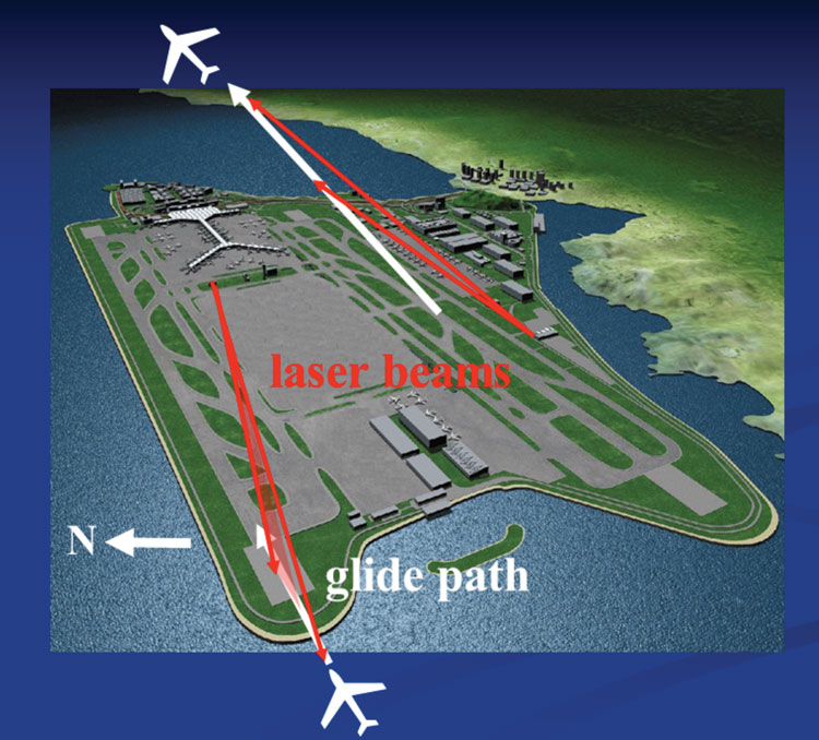
Figure 3: Dual LIDAR windshear alerting system, with a LIDAR scanning each of the two runways of HKIA
Apart from using cutting-edge meteorological equipment, HKO has also invested in the development of meteorological information delivery system. A dedicated web-based system was developed to deliver aviation meteorological information directly to end users when HKIA opened in 1998. Today, the system is already in its third generation. Apart from flight documentation and real-time weather data such as satellite and radar pictures, a wealth of products that are tailored to meet individual’s specific operational needs and decision making, such as airports below landing minima, are available. To bring weather information closer to the aeronautical user who is always on the go, a new mobile application ‘MyAeroMET’ (Figure 4) was launched on Android in late 2013 for registered users. To further extend our information services, the Observatory is also partnering with local airlines to develop Electronic Flight Bag (EFB) applications to facilitate pilots’ appreciation of weather situations in the cockpit in real-time.
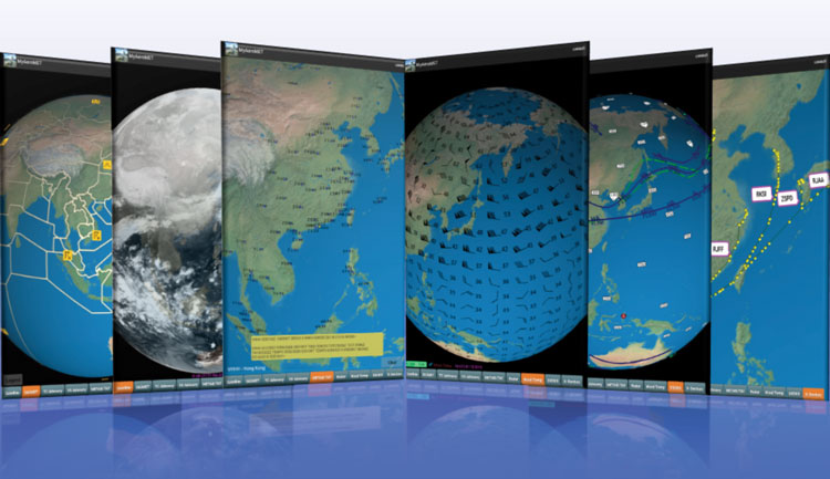
Figure 4: Portable aeronautical meteorological information displayed on MyAeroMET – a mobile application developed by the Observatory on the way towards EFB
User engagement and continuous improvement
The Observatory was among the first in the world to be awarded with the ISO 9001 certification for its quality management system for the provision of aviation weather service back in 2002 when the requirement was introduced by ICAO. This could not have been achieved without the key elements of quality management already in place before its introduction.
For example, to gauge our performance, the Observatory developed an objective verification system to measure how good our forecasts and warnings are. The system has since been shared with some 25 countries. User satisfaction is highly valued by the Observatory in the provision of weather services for aviation. User satisfaction surveys have also been carried out on an annual basis since the late 1980s to collect user comments and feedback in addition to gauging the performance of our services (Figure 5).
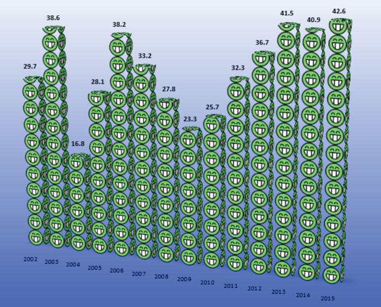
Figure 5: Long-term trend of the percentages of very satisfied service/very accurate forecast provided by HKO, as revealed in the annual customer survey
As an important source of ideas for continuous improvement in our services to meet user needs, the HKO established a Liaison Group on Aviation Weather Services with representatives from pilot associations and airlines in 1994. It allows us to better understand the needs of our users and also acts as a gateway between the local aviation community and the ICAO on promulgation of new standards and requirements and conveying user feedback.
Recognition of the effort
Our achievements in aviation weather services and the developments of weather alerting technologies have won numerous awards in the last 10 years or so. Particularly worthy of mention is the LIDAR windshear alerting system which won the Award of the Year in the Hong Kong Information and Communication Technology Awards in 2009. HKO’s work on windshear and a few other areas have also been promulgated in ICAO manuals, aviation and meteorology-related magazines and scientific journals.
Apart from serving the aviation community, HKO is also very active in participating in international matters by providing expert advice. A number of HKO’s colleagues participate in the various World Meteorological Organization (WMO) expert teams on aviation meteorology and ICAO panels and working groups. Our outstanding achievement and contribution to the aviation meteorology is the main reason behind CM Shun (joint author of this article) being elected as the President of the Commission of the Aeronautical Meteorology (CAeM) of WMO in 2010 and again in 2014.
Opportunities of future development
ICAO’s endorsement of the fourth edition of the Global Aviation Navigation Plan (GANP) and its associated aviation system block upgrades (ASBU) has started a new era. In the future ‘one sky’ environment, airlines will be looking for global service provision. There is also an international trend for the regionalisation of weather information provision to support seamless ATM. In view of the evolving user needs and the international trend, HKO is actively seeking collaboration with overseas meteorological services, in particular neighbouring services, on exchange of additional data, technological cooperation and regional service delivery etc.
To support more flexible ATM, improved situational awareness, collaborative decision making and dynamically-optimised flight trajectory planning, HKO has embarked on the development of Trajectory Based Operations (TBO) information services. TBO requires the blending of weather information of various temporal and spatial scales with ATM information to provide a seamless weather service along the whole flight trajectory.
In this regard, the HKO takes the lead in organising the WMO Aviation Research Demonstration Project (AvRDP) at a number of busy international airports in different climate regions in the next few years. The project will develop, demonstrate and quantify the benefits of end-to-end nowcasting aviation weather services for the terminal area.
The integration of meteorological information into the future globally interoperable ATM system will be realised through system-wide information management (SWIM) with the use of digital data in ICAO Weather Information Exchange Model (IWXXM) format. HKO is actively participating in the development of meteorological data representation in IWXXM format to ensure that we would be amongst the first to introduce it, so that our customers could immediately reap the benefits, such as uplinking of hazardous weather information for flight following operation. Of course, data flow can be both ways. Aircraft contain a wealth of data which we could use to improve the meteorological service. For example, using big data approach, Mode-S data from aircraft could be used to derive wind information for use in weather prediction models.
In order to boost airport capacity, HKO is undertaking a collaborative project with AAHK to study the characteristics and evolution of wake vortices at HKIA, particularly for the climate of Hong Kong. The results so obtained would be useful for further investigation into the possibility of optimizing the sequencing of the aircraft and thus potentially increasing the airport capacity.
Summary
The Observatory spares no effort in providing the best aviation weather service to its users through the introduction and in-house development of new technologies, turning challenges into opportunities for new scientific advancement. In this process, innovative research, partnership and service culture are the keys to success, and indeed they are among the core values of the Observatory. We will build on our achievements to make future technological advancement in the face of ever increasing global challenges on air traffic operation, such as regionalization of aviation weather services and the significant growth of air traffic in this part of the world.
Biographies
Chi-ming Shun was appointed as Director of the Hong Kong Observatory in 2011, Mr Shun has specialised in aeronautical meteorology since the 1990s and led a team of researchers to develop the world-first and award-winning LIDAR Windshear Alerting System for Hong Kong International Airport. In the international arena, Mr Shun is President of the Commission for Aeronautical Meteorology of the UN World Meteorological Organization. Mr Shun is also Permanent Representative of Hong Kong, China with WMO. He is also Chair of the Hong Kong Meteorological Society, Fellow of the Royal Meteorological Society, Member of the Chinese Meteorological Society Executive Committee, and Member of the American Meteorological Society.
Pak-wai Chan is a Senior Scientific Officer of the Hong Kong Observatory. He is responsible for windshear/turbulence alerting service, aviation meteorological instrumentation and numerical weather prediction. He is a Fellow and Chartered Meteorologist of the Royal Meteorological Society.

 Chief Executive Officer
 CEO
CEO Chief Operating Officer
 Head of Operations, Safety and Emergency
 Chief Strategy Development Officer
 Head of Operations
 Airport General Manager
 CEO
CEO Chief Executive Officer